Gaining knowledge usually begins with the intensive study of an object at close range. In the case of environmental changes, it is the other way round: only the view from space allows the observer to recognize and understand large-scale interrelationships. At GAF AG, the view is therefore always directed at our Earth from above.
By Monika Rech-Heider
Markus Probeck is responsible for strategic business development at Munich-based GAF AG. The business strategy of GAF with its approximately 230 employees is directly related to the view from space, just like the professional development of the Earth observation specialist. For more than twenty years, the 46-year-old geographer, as a specialist for the European Earth Observation Programme Copernicus and for environmental monitoring, has been focusing his attention on how satellite images help to meet global challenges such as climate change, to make the dramatic loss of biodiversity and tropical forests measurable and understandable - and ultimately to combat it effectively.
Emergency assistance from space
The Emergency Management Service (EMS) as one of six thematic services of the European Earth observation programme Copernicus is in continuous operation these days. "If national civil protection authorities of EU member states activate the Rapid Mapping Service in the event of natural or man-made disasters, all relevant satellite operators are immediately informed in order to provide up-to-date images of the respective affected regions of the world as quickly as possible," says Probeck.
The images from the highest-resolution optical satellites with up to 30 centimetre image resolution in combination with radar images are usually available within a few hours. Within a very short time, a preparedness team produces precise maps that give a quick overview of the extent of the disaster. GAF and its staff are part of the "Rapid Mapping Team" consisting of leading European companies, which is on duty around the clock on behalf of the European Commission to provide an up-to-date picture of the situation within a few hours in the event of disasters of major proportions.
The team has also been deployed in the case of the devastating flood of the century in the Ahr Valley in 2021, as well as in more than 600 disaster events worldwide in the last ten years. "Copernicus' Rapid Mapping Service is highly renowned internationally and is also activated worldwide after earthquakes, volcanic eruptions, storms and floods or to monitor large refugee movements. Right now, forest fires all over Europe are the main focus of EMS rapid mapping," Probeck emphasises. ""
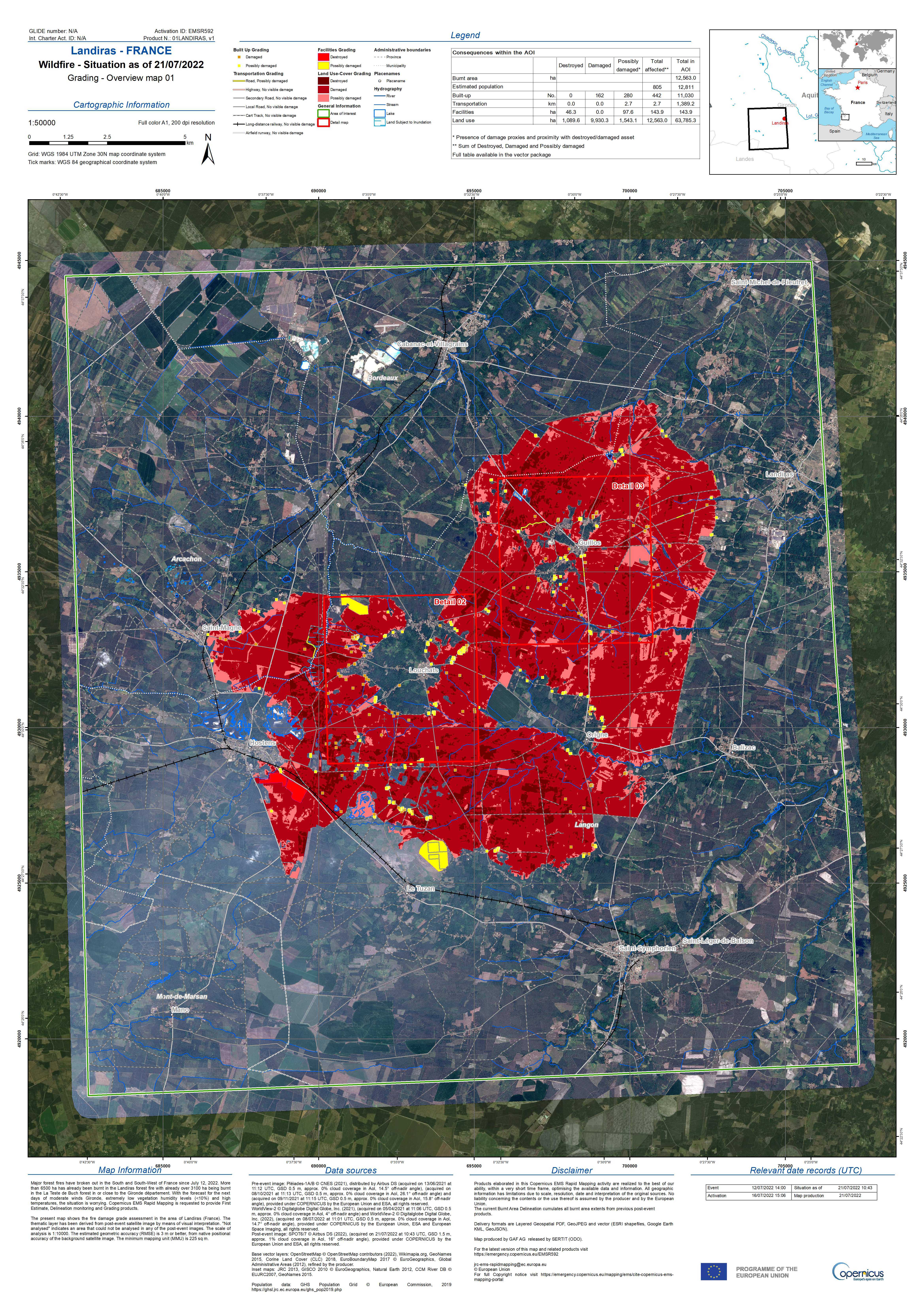
Image 1: Forest fires in France, south of Archachon, published 21.07.2022. Source: © Copernicus Programme
In addition to mapping current hazard situations, aftercare, preparation for possible future hazard situations and planning and monitoring the progress of recovery measures also play an important role in the Copernicus Emergency Management Service.
Stopping deforestation
Earth observation is considered one of the most important tools in the fight against unchecked carbon release from tropical forest deforestation and slash-and-burn agriculture. The REDD+ programme (Reducing Emissions from Deforestation and Forest Degradation), jointly supported by the United Nations and the Food and Agriculture Organisation ( FAO), helps 65 countries worldwide to protect their rainforests.
GAF has been involved in the programme for a long time: as early as 2007, the company developed the first pilot applications to help Central African countries in particular determine their historical and current deforestation rates, measure the success of forest protection measures and thus ultimately pave the way for compensation payments for avoided deforestation from the REDD+ programme. "Such compensation payments are, as far as we know today, one of the most effective incentives for achieving the climate protection goals set out in the Paris Climate Agreement, including by avoiding deforestation and associated carbon releases," Probeck adds.
The international LULUCF (Land Use, Land Use Change and Forestry) programme also aims to preserve forests as carbon sinks. Among others, the EU member states and the EU Commission are involved in this programme. In this context, GAF, together with partners, produces highly accurate time series mapping of land use and land cover in Europe and delivers it to the European Environment Agency (EEA), which monitors changes in land use and land cover and the associated changes in carbon storage in Europe.
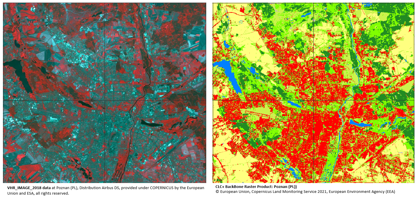
CLC Backbone
"For some years now, after a prolonged period of steady increase in forest cover in Europe, we have been experiencing a significant decline in tree cover. This is particularly due to the extreme heat periods of recent years and the accompanying drying out of the soil, pest infestations and forest fires," Probeck explains. "We can follow this very closely from space."
Detect ground movements, avoid damage
Not only acute natural disasters, but also slow ground movements can pose a danger to the population and critical infrastructure. Such movement processes, which are usually not directly perceptible to humans, are triggered, for example, by slow landslides, tectonics, mining or geothermal use. Subsidence of the subsoil and corresponding damage to buildings, traffic routes, bridges and other critical infrastructure can be the result.
With earth observation methods such as satellite-based radar Interferometry (InSAR), such ground movements can be detected over large areas, cost-efficiently and with high precision. Through corresponding time series analyses of radar images, complex movement patterns can be investigated and used for the assessment of natural geohazards, for targeted hazard prevention or also for risk and damage analyses in urban and transport planning and the insurance industry.
The recently released European Ground Motion Service (EGMS), in which GAF is involved in a consortium of leading European InSAR companies, uses continuous imagery from the Copernicus Sentinel-1 satellites. This service extends the Copernicus Land Monitoring Service (CLMS) with a new and unique pan-European product. "With the help of many consecutive radar satellite images, horizontal and vertical movements of the Earth's surface can be made visible in the millimetre range per year," says Probeck. "We as a company then also use these freely available Copernicus products to create more advanced services for local and specialised applications."
Figure 3: Ground movements (vertical in mm) at the Hambach open pit mine in the EGMS ortho product. © Copernicus Programmes.
Figure 4: Markus Probeck, Chief Business Development & Sales Officer GAF AG
GAF will again be showing its entire portfolio at this year's INTERGEO, including its latest innovative highlights. Probeck concludes: "We are happy to have been among the exhibitors at INTERGEO for many years and look forward to seeing our customers, partners and friends again in Essen from 18 to 20 October."