3D laser scanning has reinvented itself again and again in the last decade. The entire industry is benefiting from the worldwide trend of digitisation. Three INTERGEO exhibitors report how they have developed 3D laser scanning into a growing business field.
Major growth in the BIM environment
Olaf Prümm is the managing director of Lupos3D and founded the company in 2005 together with two partners. From the beginning, the founders focused on software development and services related to 3D laser scanning. Lupos3D has developed its own software, LuposScan, which is used to evaluate 3D point clouds.
The crux of evaluating point clouds is to tailor their high information density to the desired applications. Lupos3D has its customers in the architecture, archaeology, monument preservation, geology and engineering surveying sectors. From the point clouds, the employees derive 2D plans, 3D models, longitudinal and cross-sections or views of buildings or infrastructure, among other things, and bring them into formats that can be further processed by BIM and CAD programmes.
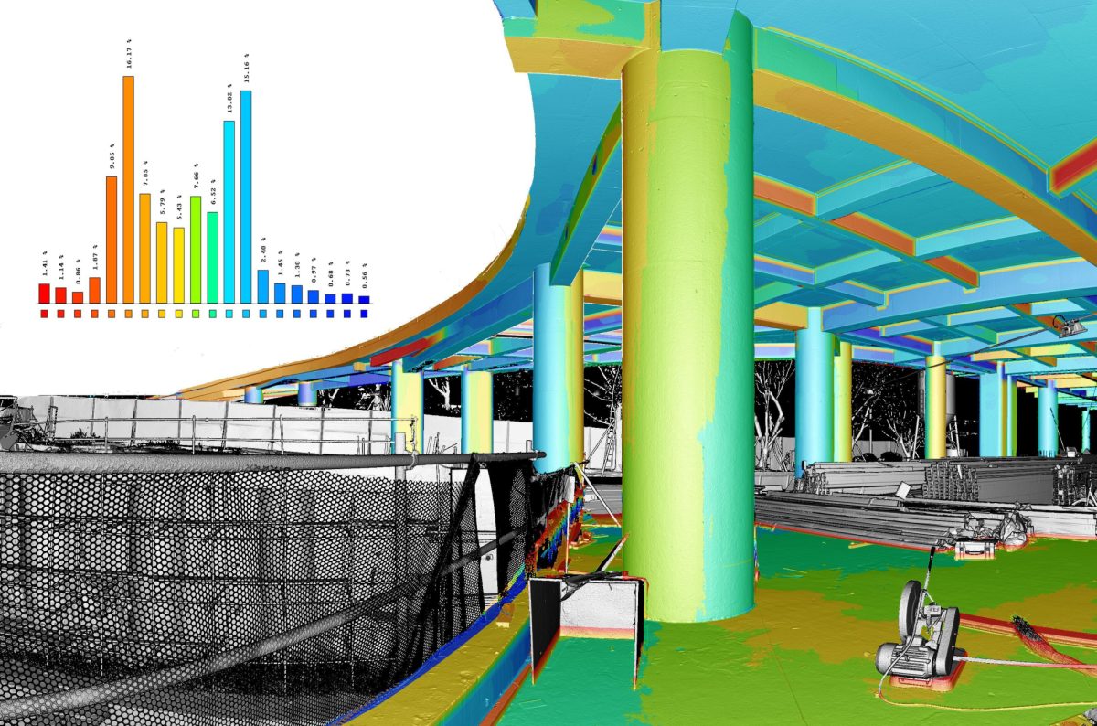
Olaf Prümm sees great growth in the BIM environment. The use of laser scanning in quality control during construction, and thus the comparison of planning with the built objects, is very much in demand. Overall, the market is developing very dynamically, according to the entrepreneur: "There is still a lot of potential for development. While the devices in terrestrial laser scanning are becoming faster and smaller, the greater potential at present is certainly in mobile laser scanning. The devices are becoming more and more accurate and have an advantage in many areas because of their much higher measuring speed and manoeuvrability." As the hardware develops, the company also receives more frequent enquiries about very specific issues. For example, Lupos3D has developed workflows to inspect manholes and sewers or to measure the size and depth of concrete excavations on buildings or bridges and roads.
Lupos3D will be exhibiting at INTERGEO: Hall 3, Stand F3.065
Bridge to the Middle East and North Africa
With its expert knowledge in the field of laser scanning and photogrammetry and the Lebanese origin of founder and CEO Dr. Khaled Nabbout, the company Mena3D builds a bridge to the Middle East and North Africa. Immediately following his doctoral thesis at the TU Dresden on the use of 3D laser scanning in urban planning, Nabbout founded the company Mena 3D. His goal was to let countries in the Middle East benefit from his know-how. So in 2013, he founded his company directly with a second office in Dubai. This was followed by branches in Qatar, Morocco, Tunisia and Lebanon.
Mena3D has focused its portfolio on solutions. The customer has a problem, Mena3D implements it with an international partner network and technical expertise: from hardware to software to executive services in the fields of laser scanning and photogrammetry. Back in 2014, Nabbout received its first major order from the Ministry of Transport in Dubai, surveying the country's transport routes with laser scanning technology.
Laser scanning has also been used for accident recording in Dubai since then. Since 2019, Mena3D has been helping the government of Kuwait to scan the whole of Kuwait. Right now, the land survey and bathymetry of Qatar is coming up. Lidar mapping is just reaching the next level, according to Nabbout: "We're surveying mines in Morocco right now with mobile laser scanning, completely autonomous and without GPS when there's no reception." According to Nabbout, the Middle East is very ambitious when it comes to digitalisation. Climate change and environmental issues in particular are driving governments to strive for complete coverage of their countries in the form of digital twins. Surveys, planning of renewable energies, transport routes or coastal protection take place on the basis of these.
Mena3D will be exhibiting at INTERGEO: Hall 3, Stand C3.031
Mobile mapping is becoming more and more accurate
Things have also been moving fast at mobile mapping and reality capture specialist NavVis since it was founded in 2013. The company aims to bridge the gap between the real and digital worlds with its mobile laser scanning workflows, especially in the building and construction, industrial and surveying sectors.
Evelyn Schmitz is Solution Manager Scanning and Surveying at NavVis in Munich. Her task is to integrate NavVis' new mobile mapping technology into existing workflows of customers in the surveying sector and to ensure that external devices also fit perfectly into their own workflows. In 2021, NavVis initiated an international survey on the status of mobile mapping in the laser scanning, surveying and AEC (Architecture, Engineering, Construction) industries and published it in the 'Mobile Mapping Report'.
According to the report, the key factors for the acceptance of mobile mapping solutions are accuracy, speed and compatibility. While the speed during data acquisition with the NavVis VLX mobile scanner is about ten times higher than with a terrestrial laser scanner, the accuracy is constantly evolving. "We have reached an average accuracy of six millimetres thanks to our SLAM algorithms, and we have reached Level of Development (LOD) 300 in modelling, which is sufficient for most applications, such as construction progress control or the replanning of buildings.
The surveying industry now has us absolutely on their radar," says Evelyn Schmitz. Ease of use, fast and accurate results and compatibility with terrestrial systems ensure a high level of acceptance in the industry.
NavVis will be exhibiting at INTERGEO: Hall 3, Stand D3.031