Yu Feng, a PhD student at the Institute of Cartography and Geoinformatics at Leibniz University in Hannover, has analysed in his thesis how images in social media can help to understand and assess the extent of a flood disaster. Yu Feng will present his results at the Intergeo CONFERENCE.
The flood disaster along the rivers in North Rhine-Westphalia and Rhineland-Palatinate vividly demonstrates the extent to which climate change is also producing extreme weather events in Germany. Timely warnings were transmitted by the European Flood Awareness System (EFAS), which was established after the floods on the Elbe and Oder rivers in 2002 as part of the European Earth Observation System COPERNICUS. But the reporting and warning chain did not reach those affected. In this context, the British researcher and co-founder of EFAS Hannah Cloke speaks in an interview with the Sunday Times of a blatant system failure.
In order to better understand flood events, the Institute of Cartography and Geoinformatics at Leibniz Universität Hannover already conducted a research project in 2017. With the help of automated methods based on artificial intelligence, Yu Feng developed a method in his doctoral thesis to determine the height of the water level during a flood based on social media feeds. Yu Feng will speak about his doctoral thesis at the INTERGEO Congress: "Flood severity mapping from Volunteered Geographic Information by interpreting water level from images containing people: A case study of Hurricane Harvey".
Mr Feng, what is the background to your doctoral thesis?
There is plenty of official information when a flood occurs. Sensor data along rivers and satellite data are used by authorities. We wanted to explore ways in which social media can be included in flash flood and flood warnings. And how they can help to better understand a flood situation in the aftermath to prevent recurrences.
And what information have you been able to extract from social media about floods?
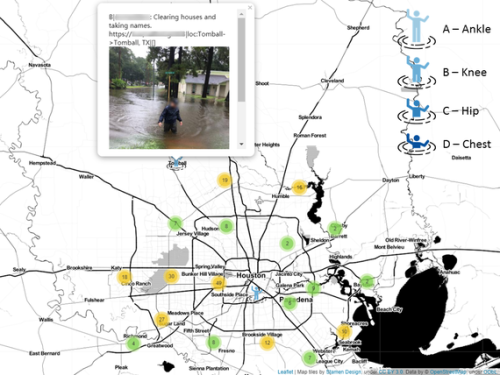
We analysed images posted by people affected by Hurricane Harvey in 2017. Based on this, I developed a method for deriving water levels with the help of artificial intelligence: the system recognises how deep people are standing in the water - up to the ankle, knee, hip or chest. The water level can then be roughly determined from this. The whole thing is intended as a supplement where there is no official data from accurate sensors.
Can this estimation of the water level be incorporated into aid organisations' reporting chains?
Posts from Twitter or Instagram can certainly serve as an additional source of information to the official information from the relevant authorities. Perhaps this method can be integrated into situation software to automatically obtain up-to-date data and visual impressions from the images. So far, however, I am not aware of such a procedure.
Mr Feng, thank you for the interview. The interview was conducted by Monika Rech-Heider.
Yu Feng is a PhD student at the Institute of Cartography and Geoinformatics at Leibniz University in Hannover. He will be speaking on this topic at INTERGEO CONFERENCE on 21.9.2021 from 16.20 to 16.40.
Klassifikationsergebnisse zur Wasserstandsschätzung


Overview of the flood intensity for Hurricane Harvey in Houston, USA 2017.