The geosciences are of great importance for the future. The environment is changing at breathless speed. The disciplines of the geosciences, and with them their corporate landscape, are setting the course for understanding interrelationships, making forecasts and deriving recommendations for action. At INTERGEO 2022 in Essen, experts from geodesy, geoinformation and land management will meet to shape the future. An overview.
By Monika Rech-Heider
Dust-dry, cracked soils as far as the eye can see. Parched river valleys and stunted crops in the fields of Spain, Portugal, France and Italy. In South Tyrol, a glacier collapse drags people to their deaths. The bark beetle relentlessly decimates Europe's coniferous forests and in Greece, as in previous years, forest fires devastate the parched landscape. The press service of Europe's Copernicus satellite programme has just reported the third hottest June since records began. Worldwide, it is 0.31 degrees Celsius warmer than the average between 1991 and 2020. And then comes bad news from GEOMAR, the Helmholtz Centre for Ocean Research in Kiel: the Rhine could soon run dry in the summer.
Exactly one year ago, only one topic dominated the media: what we call a flood of the century devastated villages and towns along the rivers in North Rhine-Westphalia and Rhineland-Palatinate. 14 July 2022 marks the anniversary of the flood event that swept away more than 180 people and caused billions in damage after heavy rainfall. Even today, residents along the Ahr and Erft rivers are struggling with the consequences of the flood. The series of devastations that must be interpreted as climate consequences could be continued.
With every piece of bad news and the recurring, urgent appeals of the Intergovernmental Panel on Climate Change, it becomes clearer what a fundamental contribution geosciences play in observing, analysing, forecasting and, above all, adapting to global climatic changes.
As an international meeting place for experts from geodesy, geoinformation and land management, INTERGEO is one of the events where worldwide expertise on the subject of environmental monitoring, early warning systems and disaster management is gathered in one place. The global challenges demand common answers. We present some of them.
Part One: Esri: The Battle for the White Spots
Daniela Wingert of technology and GIS provider Esri is one such expert. As team leader for education and higher education and responsible for the area of non-profit organisations and disaster response, she deals every day with how geoinformation helps to better understand planet Earth. "Mapping the sometimes drastic changes or concrete events enables our society to react appropriately to new situations," says the surveyor. The social task of geoscientists is growing immensely in these times, which becomes clear when Daniela Wingert reports on Esri's activities.
According to her, the global company is working with its technology and in interaction with the entire industry to build nothing less than a "Digital Twin Earth". This digital image of the Earth will be fed with data from all channels in order to understand and derive recommendations for action. Remote sensing, sensor data, crowd-based information, drone data - they are all being fed into the Digital Twin Earth worldwide to prepare for what is to come. Imagine a distillation process in which a highly concentrated, noble, mixture is created from the basic ingredients. How can we counteract the increasing deforestation? How do we respond as efficiently as possible to natural or man-made disasters? How can we slow down the dying of native forests and how do we adapt the forest to higher and medium temperatures and heat phases? How do we better understand the interrelationships and movement patterns of the oceans? These are all questions that geoscientists around the world are tackling with Esri technology.
Gaining an overview
With ArcGIS technology, Esri wants to make its contribution to bringing the world together in an active community. In the ArcGIS Living Atlas of the World, the company brings together what is now the world's largest collection of geoscientific information in the form of maps, data, apps and layers and makes it available to the international community of scientists and researchers free of charge. The Sentinal data on land cover on land cover are just as much a part of it as the worldwide topography und bathymetry or the Ecological Marine Units. Digital twins are currently the focus of much of the company's attention. Probably the most important Digital Twin maps questions about the environment, ecosystems, nature, climate and oceans. "Thanks to Earth observation, we have gigantic amounts of data and also increasingly better update rates. Sensors on land and at sea make it possible to monitor the ecosystems of our planet in the best possible way. But even from all this data, useful information must first be generated with analysis tools," says Daniela Wingert. Change detection based on artificial intelligence draws attention to critical changes. The Digital Twin Earth is thus the basis for nature conservation, sustainability programs, science and research and serves agriculture to improve land management. It helps to understand environmental pollution and to monitor and protect animal species. The Environmental Twin can also be used for the management of nature parks and to steer activities towards sustainability.
Disaster Response
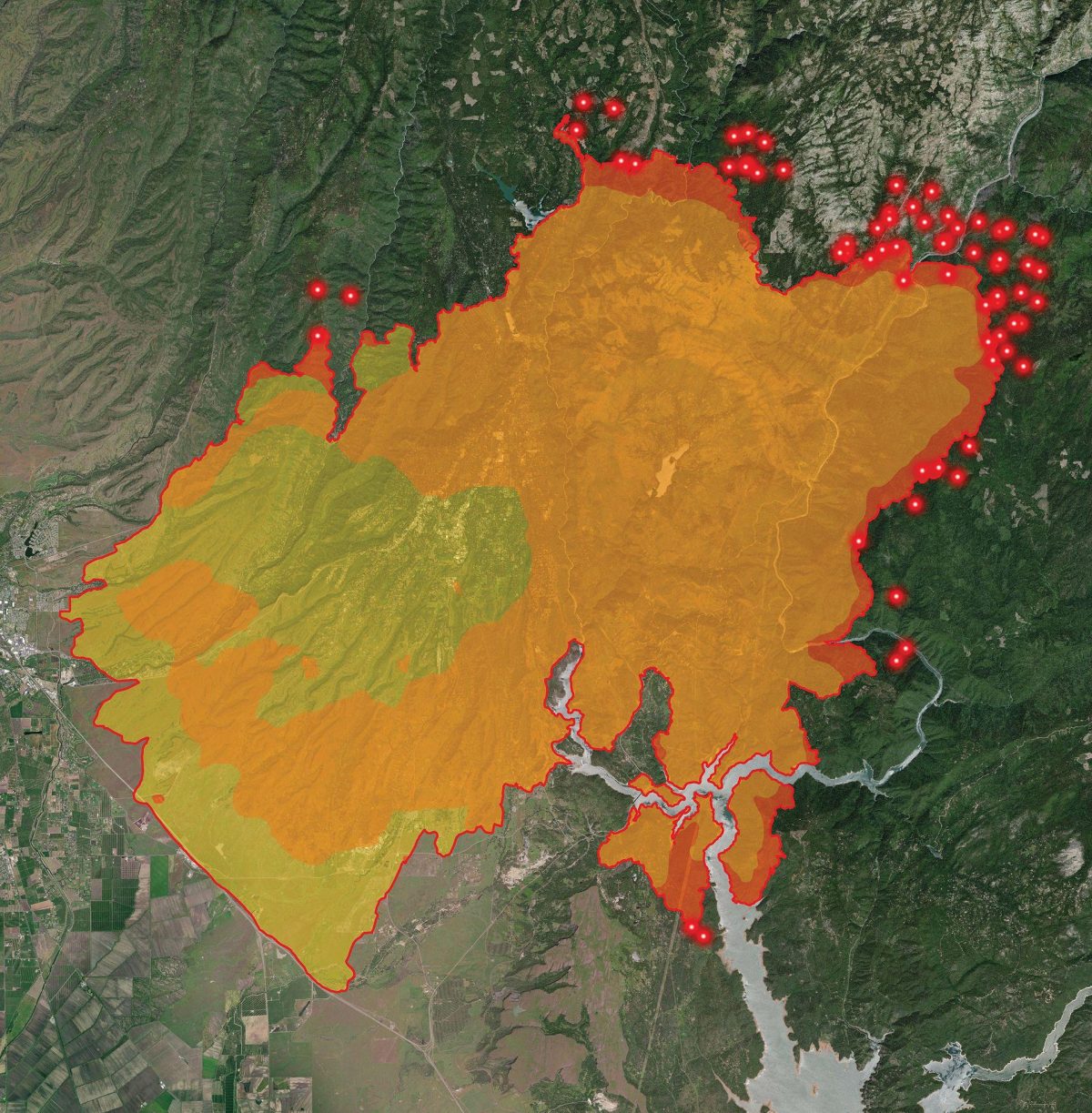
The example of flooding in the Ahr valley. In response to disasters, every minute counts. Relief organisations received aerial and satellite imagery within hours of the event, which provided an accurate situational picture, i.e. a precise overview of the situation and the extent of the damage. Complementary to the information provided, the Living Atlas is a key factor in the rapid and successful response to disasters such as flash floods, earthquakes, forest fires. Initiated by the Esri Disaster Response Programme, the countless helpers were able to feed crowd-based damage into the system, so that with the help of the resulting situation picture on the community dashboard, those responsible could make decisions and coordinate measures. Where are bridges destroyed, which roads are flooded? These questions found answers on this basis in order to bring relief supplies to the affected areas.
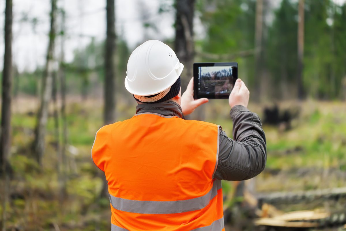
Forestry in Germany
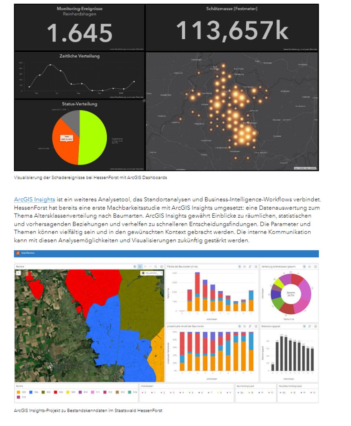
The State Office of Hessenforst relies on rapid communication through networking of forestry employees. With the mobile bark beetle app, the foresters are in direct communication with each other. Once a bark beetle infestation is identified, they immediately initiate the necessary measures to prevent it from spreading. The infested areas are isolated, the trees felled and removed. With the help of further tools such as ArcGIS Dashboard and ArcGIS Insights, the damage events can be visualised and interpreted spatially and on a virtual control platform (dashboard). The forest management thus learns visually and in an easily understandable way when and where damage has occurred and which operational and strategic decisions are to be derived.
Kartierung der Tiefsee
Am 8. Juli 2022 ging es im Indischen Ozean vor der Küste des Inselarchipels der Malediven im Auftrag des Esri-Programms „Map the Ocean“ in die Tiefe. Der Tauchgang führte südöstlich der Marianeninseln in zehn Kilometer Tiefe. Ziel ist es, Daten zu sammeln und damit zum Erfolg eines einzigartigen, kollaborativen Megaprojekts der UN und der Nippon Foundation beizutragen. Map the Ocean ist Teil der „United Nations Decade of Ocean Science for Sustainable Development“, die das Projekt „Mapping the Ocean“ ausgerufen hat. Auch die japanische Nippon Foundation arbeitet mit „Seabed 2030“ am gemeinsamen Ziel, bis zum Jahr 2030 eine hoch aufgelöste Karte des Meeresbodens zu erstellen. Mehr als 70 Prozent der Erde sind mit Wasser bedeckt. Dem gegenüber steht, dass bislang nur 20 Prozent dieser Oberfläche kartiert sind. Weiße Flecken überall. „Wir brauchen die Informationen aus den Tiefen der Ozeane, um die Prozesse besser zu verstehen“, so Daniela Wingert. Aus den Daten erhoffen sich die Forscher unter anderem bessere Frühwarnsysteme für untermeerische Vulkanausbrüche, Erdbeben sowie ein besseres Bewusstsein über die Ökosysteme der Tiefsee.
Mapping the deep sea
On 8 July 2022, the Esri "Map the Ocean" programme went deep in the Indian Ocean off the coast of the island archipelago of the Maldives. The dive led southeast of the Mariana Islands to a depth of ten kilometres. The aim is to collect data and thus contribute to the success of a unique, collaborative mega-project of the UN and the Nippon Foundation. Map the Ocean is part of the "United Nations Decade of Ocean Science for Sustainable Development", which has proclaimed the project "Mapping the Ocean". The Japanese Nippon Foundation is also working with "Seabed 2030" on the common goal of creating a high-resolution map of the ocean floor by 2030. More than 70 percent of the earth is covered with water. On the other hand, only 20 percent of this surface has been mapped so far. White spots everywhere. "We need the information from the depths of the oceans to better understand the processes," says Daniela Wingert. Among other things, the researchers hope that the data will lead to better early warning systems for submarine volcanic eruptions, earthquakes and a better awareness of the ecosystems of the deep sea.
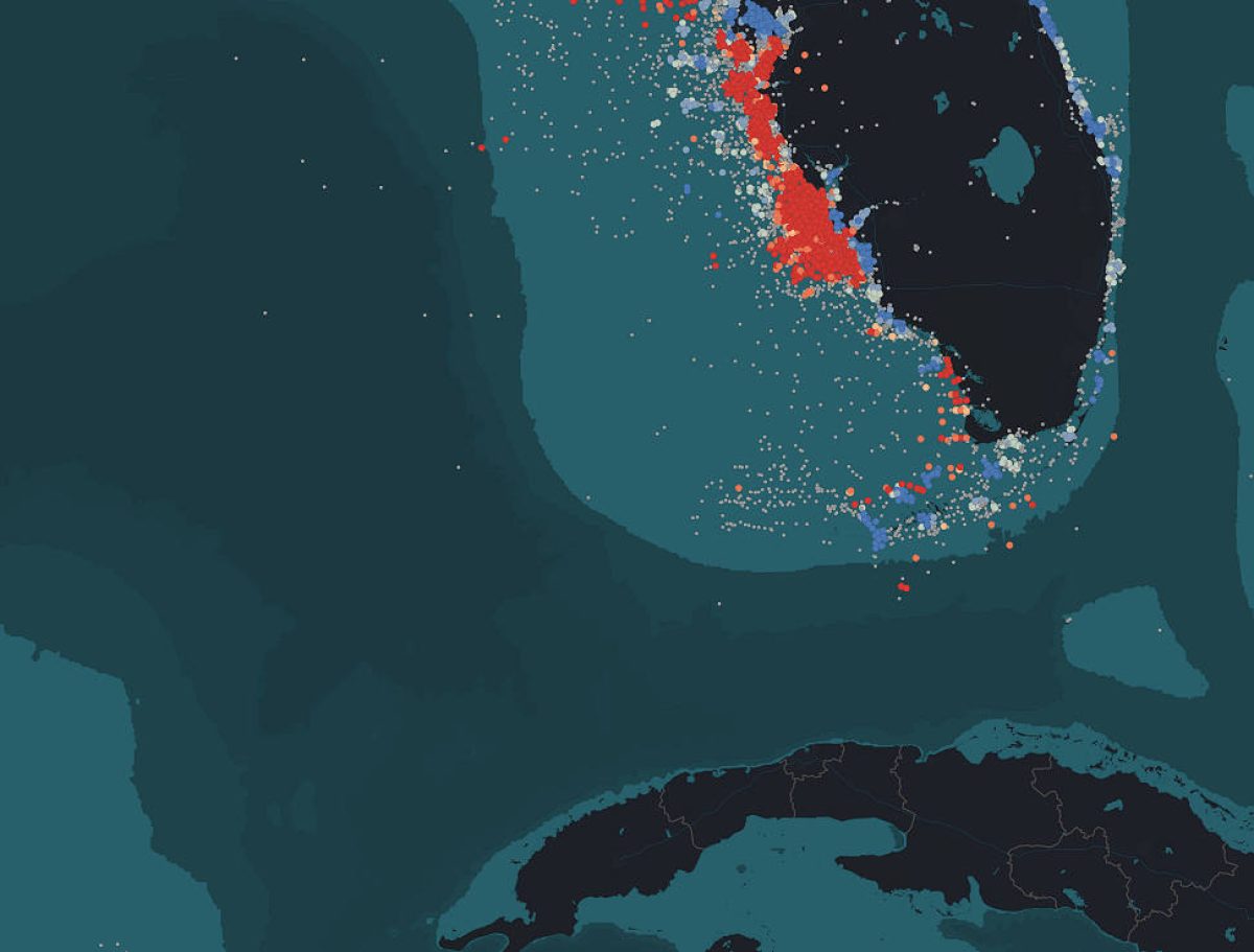
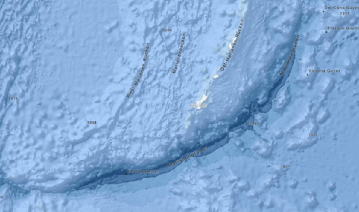
Abb. Mariana Trench and Challenger Deep
Esri, GEBCO, DeLorme, NaturalVue | Esri, HERE, Garmin, FAO, NOAA, USGS, Powered by Esri
Education and young people
In her role as Team Leader Education and Higher Education, Daniela Wingert is particularly interested in bringing children and young people together with the world of geoinformation. In a joint project, 9th and 10th graders studied the microclimate of the city of Osnabrück. As part of an internship, data for the city of Berlin was prepared in a story map. "We are always amazed at how committed the pupils are to solving tasks based on our ArcGIS platform and what sometimes surprising ideas are discussed afterwards," says Daniela Wingert. At the annual summer camp for pupils on the island of Föhr, the young people learn to map fauna and flora and to interpret them in GIS. "This year we are celebrating our 15th anniversary of the summer camp. The data collection has grown so much in the meantime that the research of the Schleswig-Holstein Wadden Sea National Park benefits from it with a time series analysis on seagrass occurrence.
Environmental and climate protection have been high on Esri's agenda since the company was founded. "We work together with science, politics and non-profit organisations worldwide to erase the white spots in our knowledge and to positively shape the future for our planet and our society," says Daniela Wingert.