The Canadian company PRESAGIS provides 5D information for visualisation and simulation. The context as the fifth level classifies situations according to the "how" and "why". This also requires artificial intelligence! Carlos Carpio from PRESAGIS in an interview.
Presagis is a worldwide operating Company based in Canada. What exactly do you offer?
Presagis is a global leader in 3D advanced modelling and simulation software. We have recently launched VELOCITY 5D (V5D), a cloud-based platform that quickly and automatically converts massive volumes of 2D geospatial data into high-fidelity 3D digital twins. V5D leverages artificial intelligence and game engine technology to run complex visualization and simulation scenarios that derive context from the digital twins.
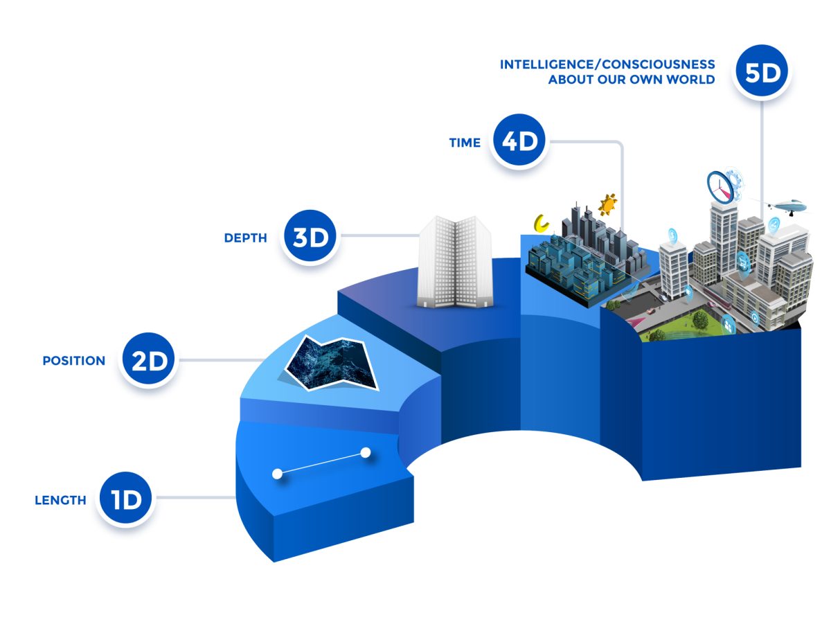
You call the fifth level, CONTEXT, meaning the intelligence/consciousness about our world. What does it mean?
From a geospatial perspective, 2D and 3D traditionally answer the question of “Where” an object is located or an incident occurred – in three dimensions. When you add in historical data, such as multi-temporal satellite imagery, the question of When is answered. The fifth dimension, or Context, is derived by adding other data sources – demographics, IoT sensor inputs, infrastructure performance, and statistics (urban growth, crime, building development, etc.) to reveal patterns of life, human interaction, crowd behavior, or traffic flow. This is the Context that answers the questions of Why or How something occurred or is located at a specific spot. Once you know Why, you can begin to predict future events.
So, the digital twin or virtual environment is a lot more then a 3D-Model?
Absolutely, a traditional 3D model is a static representation of an ecosystem, city, or nation. But the digital twin – at least the kind created by V5D – is a dynamic super-realistic visualization where features such as trees, structures, and vehicles, can be added or deleted in real time so that different scenarios can be simulated. Equipped with 5D contextual information that answers the How and Why questions, users can simulate the impact specific changes will have on their ecosystem to reveal risks, challenges, and conditions that may result from their decisions. This type of predictive analysis, facilitated by V5D, ultimately yields better decision making.
How do you use AI for interpreting the model and make it ready to give predictions?
No digital twin is perfect because there is always missing data – perhaps gaps in historical information or geospatial layers that simply haven’t been collected. AI is ideal for identifying where key data is missing. Sometimes AI can intelligently fill in those gaps, but it can also prompt the user to input the necessary information. Such is the case with V5D where built-in libraries of features and objects can be selected to supplement a created Digital Twin. This is critical for enhancing the digital twin with alterations that represent possible future changes so their impact can be predicted by the simulation algorithms.
What are the biggest challenges in including the artificial intelligence in your models?
There are two main challenges in deploying AI in simulations. The first is ensuring the input data has been properly “cleaned” so that outputs are accurate. The second is choosing the right AI algorithms for the desired simulations or predictions. For this reason, Presagis has equipped V5D with a variety of algorithms to simulate a multitude of conditions, environments, and scenarios. And if the user can’t find the right one in our platform, V5D is flexible and open to accommodate third-party simulations.
Could you give us two short examples, where your application is successfully used?
In its beta development, V5D has been successfully used to generate high-fidelity digital twins for a wide range of application areas - Smart City Management, Large Area Mapping, Defense, Infrastructure/Utility Security, Asset Tracking, Disaster Preparedness, and Urban Planning. The best application that highlights the speed of V5D was a recent project where a client input dozens of complex geospatial data sets in a variety of formats, types and structures to create a nationwide digital twin in a matter of hours, not days. The second example of V5D’s predictive capabilities is disaster preparedness. Officials have used our digital twins to determine how different response scenarios will influence outcomes during emergencies, such as floods and wildfires. It’s important to note that V5D simulations allow users to alter every variable in a given disaster situation – response tactics of emergency personnel, physical infrastructure in the impacted area, and changing behavior of flood waters or fire due to dynamic factors such as wind or precipitation.
More Information: https://www.presagis.com/en/