
The integration of video photogrammetry into the CHCNAV i89 and i93 GNSS Hybrid Smart Rover represents a significant leap forward in achieving comprehensive 3D mapping and surveying projects. More than just an add-on capability, this integration effectively bridges 3D GNSS IMU-RTK surveying and 3D LiDAR + RGB airborne surveying, joining complementary data sources for more accurate visual representation.
Convergence of Airborne LiDAR Surveying and Terrestrial GNSS: Efficiency and Accuracy in 3D Mapping and Construction Projects
Recent technological advances have changed the landscape of surveying. GNSS receivers, once used primarily to collect or stake out 3D point coordinates, have seen significant performance improvements. Seamless integration of tightly coupled, interference-free IMUs into GNSS devices enables real-time correction of ground-based coordinates with survey-grade accuracy. The latest integration of professional cameras into the CHCNAV i89 and i93 IMU-RTK receivers pushes the boundaries further, enabling precise georeferenced images stream capture directly in the field.
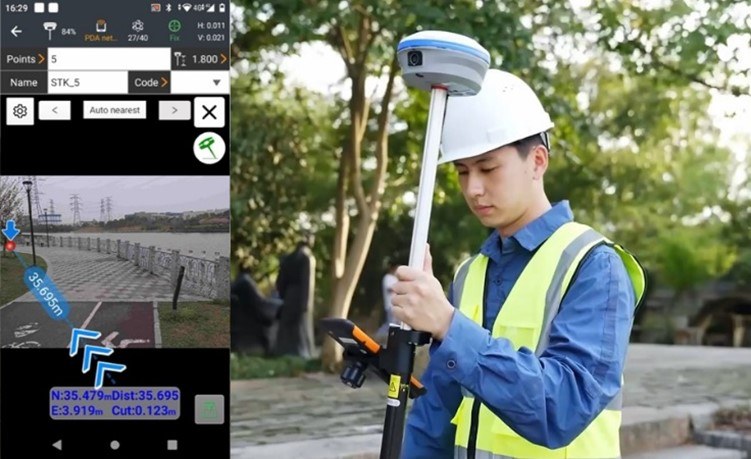
OVERCOMING GNSS SURVEYING CHALLENGES WITH 3D NAVIGATION AND STAKEOUT
The i89 GNSS-IMU is a cutting-edge surveying tool that seamlessly integrates two premium global shutter cameras with video photogrammetry technology. It quickly delivers survey-grade 3D coordinates from real-world video capture, simplifying the surveying of previously challenging locations such as those obstructed by signals, under overpasses, under eaves, or near utility poles.
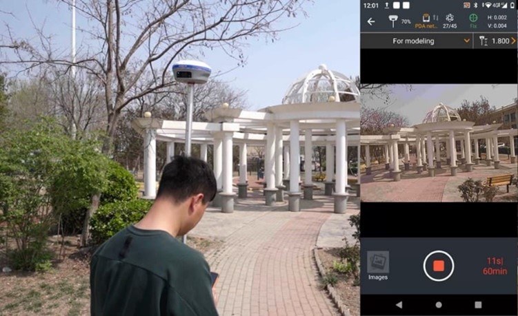
STREAMLINING 3D MODELING WORKFLOW THROUGH COMBINED AERIAL AND TERRESTRIAL IMAGERY
The i93 receiver complements aerial surveys generated from oblique imagery. Aerial imagery often has distortions, gaps and blur due to the camera angle on drones. The i93 Visual GNSS addresses this by capturing dynamic video with POS information. The i93 and UAV data are then fused to create a joint model, and automated processing in popular modeling software delivers more accurate 3D models in a matter of hours.
Accessible and Affordable CHCNAV Smart Rover with GNSS, IMU and Video Technologies
The i89 and i93 Visual GNSS Rovers provide an ideal solution for professionals looking to perform high-precision 3D surveying and modeling tasks quickly, accurately and cost-effectively. In the era of convergence towards 3D surveying, mapping and engineering, the CHCNAV Visual GNSS RTK Series is proving to be an 'must have' tool, enabling field crews to perform a wide range of tasks from simple point measurement to complex volume computation and joint 3D reality capture.